การศึกษาเส้นทางข้ามคาบสมุทรภาคใต้ตอนบน
A STUDY ON TRANS - PENINSULAR ROUTES ON THE UPPER COASTS OF SOUTHERN THAILAND
Damrong Journal, Vol 11, No.2, 2012

บทคัดย่อ:
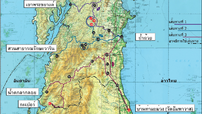
บทความเรื่องนี้มี วัตถุประสงค์เพื่อศึกษาวิเคราะห์ข้อมูลและหลักฐานที่ได้จากแหล่งสำรวจขุดค้นทางโบราณคดีในทุกอำเภอของจังหวัดชุมพร ระนอง และอำเภอท่า นะในจังหวัดสุราษฎร์ธานี นำมาใช้ในการสร้างแผนที่และข้อสันนิษฐานการใช้เส้นทางข้ามคาบสมุทรระหว่างฝั่งตะวันตก(อันดามัน)ไปยังฝั่ง ตะวันออก(อ่าวไทย) ตั้งแต่สมัยก่อนประวัติศาสตร์ยุคหินใหม่ (ประมาณ 500 ปีก่อนพุทธกาล – พุทธศตวรรษที่ 5) จนถึงสมัยธนบุรีและรัตนโกสินทร์ (ประมาณพุทธศตวรรษที่ 24 - พุทธศักราช 2452) ผลการศึกษาข้อมูลจากแหล่งโบราณคดีบนพื้นที่ที่ดำเนินการศึกษาจำนวน 70 แหล่ง ปรากฏการใช้เส้นทางข้ามคาบสมุทรใน 3 ช่วงสมัย ได้แก่ สมัยก่อนประวัติศาสตร์ยุคหินใหม่ (ประมาณ 500 ปีก่อนพุทธกาล - พุทธศตวรรษที่ 5), สมัยแรกเริ่มประวัติศาสตร์(พุทธศตวรรษที่ 5-11) และสมัยธนบุรีและรัตนโกสินทร์ (ประมาณพุทธศตวรรษที่ 24 - 25) จำนวน 5 เส้นทาง คือ เส้นทางกระบุรี – ทุ่งตะโก และเส้นทาง เมืองระนอง – ทุ่งตะโก ในสมัยก่อนประวัติศาสตร์ยุคหินใหม่, เส้นทางกะเปอร์ – ทุ่งตะโก / หลังสวน พบการใช้เส้นทางทั้งสามช่วงสมัย, เส้นทางภูเขาทอง – ทุ่งตะโก ในสมัยแรกเริ่มประวัติศาสตร์ และเส้นทางกระบุรี( ปากจั่น ) – ปากนำ ชุมพร ในสมัยธนบุรีและรัตนโกสินทร์
นอกจากนี้ยังปรากฏเส้นทางที่อาจมีการใช้งานอีก จำนวน 3 เส้นทางคือเส้นทางกะเปอร์ - ท่าชนะ เส้นทางปากจั่น- เขาสามแก้วและเส้นทางเมืองระนอง - เมืองหลังสวน (ในสมัยก่อนประวัติศาสตร์ยุคหินใหม่, สมัยแรกเริ่มประวัติศาสตร์, สมัยธนบุรีและรัตนโกสินทร์ ตามลำดับ) ซึ่งเส้นทางเหล่านี้ ควรได้รับการศึกษาค้นคว้าเพื่อยืนยันถึงการใช้เส้นทางในโอกาสต่อไป
ABSTRACT:
The objective of this paper is to apply the analysis of the results of archaeological data and evidence from surveys and excavations at sites in Chumphon and Ranong provinces and Tha Chana district in Surat Thani provinces in order to propose a site mapping model of the trans–peninsular routes between west cost (Andaman) and east coat (Gulf of Thailand) on the upper coast of Southern Thailand from the prehistoric period, ca. 1000 BCE to 1909 CE.
There are 70 sites found in the area that reveal use during three periods: the prehistoric period, ca. 1000 BCE to the first century BCE, the early historical period, ca. The 1st- 6 th centuries CE and the Thonburi and Rattanakosin period, ca. 18 th century to 1909 CE. The five trans – peninsular routes which were active are as follows : 1) the Kraburi – Thung Tako route(the prehistoric period), 2) the Muang Ranong – Thung Tako route (the prehistoric period), 3) theKapur – Thung Tako / Lang Suan route (three period), 4) the Phu Khao Thong – Thung Tako route (the early historical period), 5) the Kraburi (Pak Chan) - Pak Nam Chum Phon route (the Thonburi and Rattanakosin period) The possibility of the three trans – peninsular routes : the Kapur – Tha Chana route (the prehistoric period), the Pak Chan – Khao Sam Kao route (the early historical period) and Muang Ranong – Muang Lang Suan route (the Thonburi and Rattanakosin period) should be take into consideration for further study.