สารสนเทศภูมิศาสตร์ สถานที่ตามเส้นทางเสด็จในหนังสือ “เที่ยวเมืองพระร่วง”
“TEAW MUANG PHRA RUANG”, THE ROYAL TRAIL, GEOGRAPHICAL INFORMATION
Damrong Journal, Vol 11, No.1, 2012

บทคัดย่อ:
การวิจัยครั้งนี้มีวัตถุประสงค์
(1) จัดทำแผนที่และทะเบียนแสดงตำแหน่งสถานที่ตามเส้นทางเสด็จ “แนวถนนพระร่วง” โดยใช้เทคโนโลยีภูมิสารสนเทศ (2) รวบรวมรายชื่อสถานที่ที่ปรากฏในพระราชนิพนธ์ “เที่ยวเมืองพระร่วง”
กระบวนการเทคโนโลยีภูมิสารสนเทศ ประกอบด้วย 1. การรับรู้จากระยะไกล (Remote Sensing- RS) 2. ระบบกำหนดตำแหน่งบนโลก (Global Positioning System- GPS) และ 3. ระบบสารสนเทศภูมิศาสตร์ (Geo¬graphic Information System- GIS) แผนที่ภูมิประเทศมาตราส่วน 1:50,000(ชุด L7017 และ L7018) กรมแผนที่ทหาร แผนที่ภาพถ่ายออร์โทสีเชิงเลข มาตราส่วน 1:25,000 โดยนำรายชื่อสถานที่ที่ได้จากพระราชนิพนธ์ประมวลผลในระบบภูมิสารสนเทศสนับสนุนการวิจัยในอนาคตและวิเคราะห์อภิปรายผลการศึกษาใช้รูปแบบของแผนที่และทะเบียนแสดงตำแหน่งสถานที่ต่างๆพร้อมกับการพรรณนาเชิงวิเคราะห์
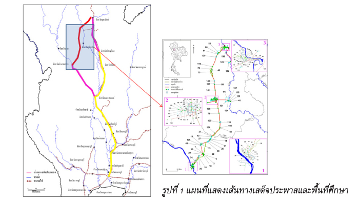
ผลการวิจัยพบว่า (1) สามารถรวบรวมรายชื่อที่ปรากฏในหนังสือเที่ยวเมืองพระร่วงได้จำนวน 449 แห่ง ตามเส้นทางเสด็จประพาสจากกรุงเทพ-มหานคร ผ่านนครสวรรค์ กำแพงเพชร สุโขทัย อุตรดิตถ์ พิษณุโลก พิจิตร รวมระยะทางประมาณทั้งสิ้น 644 กิโลเมตร และรายชื่อที่ปรากฏในช่วงการเดินทางจากกำแพงเพชรถึงศรีสัชนาลัย จำนวน 259 แห่ง (2) สามารถกำหนดตำแหน่งลงบนแผนที่และทะเบียนตามเส้นทางเสด็จจากกำแพงเพชรถึงศรีสัชนาลัย จำนวน 145 ตำแหน่ง โดยได้นำเทคโนโลยีภูมิสารสนเทศ เข้าประยุกต์ใช้ในการศึกษาครั้งนี้ ซึ่งได้ช่วยในการตัดสินใจ แก้ไข และตรวจสอบได้รวดเร็วยิ่งขึ้น และได้พบว่าแหล่งโบราณคดีต่างๆ จากที่ได้เสด็จในปี 2450 ทำให้มีการสำรวจและอนุรักษ์แหล่งโบราณคดีตลอดจนมีการศึกษาเพิ่มเติมอย่างต่อเนื่องในปัจจุบัน
ABSTRACT:
This research aimed to apply Information Technology to: 1) locate places cartographically via Geomatics; 2) store and compile place names that appear in the Royal literary work Tiew Muang Phra Ruang (Phra Ruang City Journey) that follows the Royal route called the Phra Ruang Route. The Geomatic and Information Technology processes comprised of: 1) Remote sensing (RS); 2) Global PositioningSystem (GPS); 3) Geographic Information System (GIS); the geographic map scale was 1:50,000 (Series Number L7017 and L7018), as used by the Royal Thai Survey Department, and the Orthophotomap scale 1:25,000 . The names of the places from the Royal literary work were analyzed, discussed and compiled into cartographic form. Next, an inventory of the names of the places along the Royal routes, was constructed, analyzed and described to support the research. The results revealed that: 449 places were found on the journey’s route in Tiew Muang Phra Ruang from Bangkok through Nakhonsawan, Kampaengphet, Sukhothai, Uttaradith, Pitsanuloke to Pichit, totaling 644 Kilometers; 259 names were found along the route from Kampaengphet to Sri Satchanalai; 145 places were located on the map from Kampaengphet to Sri Satchanalai. Information technology processes were found to be useful in helping to make decisions, checks and corrections, and especially to quickly achieve accuracy. Additionally, the archaeological sites that were found from the Royal literary work in 1907 were surveyed, conserved and opened up to study.